WELCOME TO AOTEA HARBOUR - AOTEAROA ~ NEW ZEALAND
Waahi tapu refers to land of special spiritual, cultural and historical significance to the tangata whenua (indigenou people) of Aotearoa, and for us, the tangata whenua of Aotea.
These are often sacred remnants from pre-European days and can include buildings, swamps, cultivation areas and pa sites and recognises the rich history of the area and the high esteem in which they are regarded.
Unfortunately, many of our waahi tapu are now in the hands of private land owners. While some respect and honour waahi tapu, others have desecrated the sites for contemporary uses, with permission from government authorities. This is a struggle that we continue to endure.
EXCAVATIONS AT AOTEA, WAIKATO,
1972-75
Aileen Fox and Richard Cassels
Records of the Auckland Institute and Museum
Vol. 20 (23 Decembr 1983), pp. 65-106 (42 pages)
Published by: Auckland War Memorial Museum
The excavation of four prehistoric terrace sites on the Waikato coast, near Aotea Harbour, is described. The settlement dates to the late fifteenth or early sixteenth century A.D. The excavations shed light on the nature of undefended terrace settlements. Features identified include a sleeping house, a cooking shed, working areas and a variety of storage pits. An economic analysis shows the importance of stored horticultural produce and the lesser importance of shellfish and fish.
Below is a summarised version of the findings with mainly quotes and maps from the article itself.
The full Journal Article is available via the link provided above.
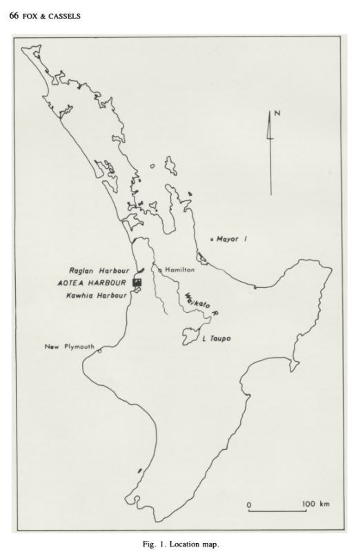
THE SETTING
"The north head of Aotea Harbour is the tip of a long peninsula extending for some 8km along the west coast as far as the Toreparu Stream. The dominant feature of the relief is the 152 m (500 ft) high bluff of Manuaitu pa built on an old basaltic dome, a formation which continues south-west towards the coast at Taranaki Point (Fig 2). South of Manuaitu, the ground slopes gently down towards the Head until it meets with the line of massive sand dunes to 91 m (300 ft)."
Location Map
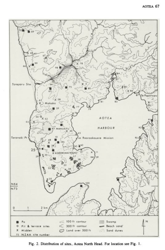
Distribution of sites, Aotea North Head
"The loose surface sands are still moving north and eastwards, driven by the prevailing south-west winds and have engulfed remains of Maori occupation, including Koreromaiwaho pa (N64/8). The variety of the geological formations provided some advantages for early Maori settlers and is reflected in the stone artefacts found during excavations (see Catalogue, Figs 17-23).
… the top soils were improved and deepened for Maori cultivation by the addition of fine sands dug from below the ash in numerous “burrow pits”. Today, the area is reclaimed grassland, providing a windswept pasture that is almost treeless…
…Examination of the charcoals from the excavation (Appendix 4, below) showed that there were some forest trees, tawa and rimu (11%), as well as kanuka (16%) growing in the vicinity in the late 15th and 16th century, the remainder being from shrubby growth, mainly Hebe sp. (23%) and Coprosma (7.6%). Pohutukawa was represented only in a sample from the topsoil near the site. The Maori need for house timbers, for palisades, and for firewood, as well as land clearance for cultivations, will have undoubtedly contributed to the loss of the coast forest formerly existing in this area.
Other natural resources available to early settlers in the area were the extensive beds of shellfish; at the present time there are tuatua and mussels on the Tasman coast, pipi in the sands of the harbour entrance, and cockles throughout the harbour (Cassels 1973:fig.1). Excavation showed that all these were exploited by the Maori population. Eels would be obtainable from the streams to the harbour as well as from the Toreparu and Ruapuke streams.” p68
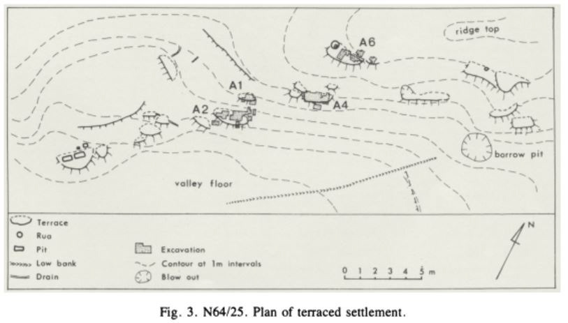
“The site chosen for excavating was a group of terraces on the south-facing slopes of a shallow dry valley and about 200 m inland from the present cliff top...
The valley was selected because it was one of the few with terraced settlements surviving in the area (Fig. 2) which had now been heavily ploughed and because there were signs of cultivations as well as ‘borrow pits’ near by. Shell midden indicative of occupation was exposed on the outer edge of some terraces and there were surface indications of storage pits. ..
The visible remains of the settlement consist of some 20 terraces spread out over a kilometre of the landscape and sited from top to bottom of a gentle slop, 10 m high ...
The terraces tend to occur in groups with one large one 20-30 m long associated with two or three smaller ones ...” p69
page 70
THE EXCAVATIONS
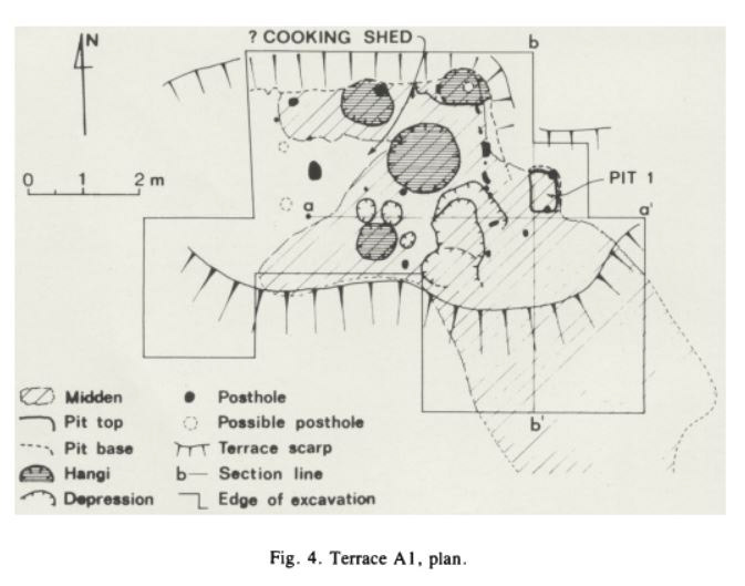
“This was a small rectangular terrace measuring 10 x 4 m dug into the hillside with a conspicuous spill of shell midden exposed at the east end on the outer slope. It was close to the larger terrace A2 and slightly above it, and with a third terrace further down the slop, which was not investigate, made up a characteristic group.
Test bores were first made to determin the extent of the midden...
In general the midden was found to consist of pipi shells, with occassional lenses of cockles; it was about 30-35 cm deep...
The midden extended as a thin layer towards the centre of the terrace where it was overlaid by and mixed with pockets of charcoal, burnt stones and ash, the thow-out from a series of hang (Fig 5)...
It was found that an area had been heavily used for cooking in circular hangi dug into the sandy loam to a depth of 6-12 cm. The largest, in the centre of the terrace, was 65 cm in diameter...
Beneath the thick midden on the front of the terrace, there were other hollows (marked as depressions on Fig. 4), probably also the remains of hangi.
On the firm ground at the back of the terrace, a series of postholes was found, indicating a rectangular timber construction measuring ca. 4 x 3 m. The north wall was at the foot of the scarp; one of the postholes 15 cm deep cut through a hangi and was visible at its base, showing that this was a secondary construction. The east wall consisted of seven small irregularly spaced holes, probably for slender uprights supporting panels of woven raupo. The intersection of the north and east walls as thus defined lay in the centre of another hangi, where an angle post has been conjectured on Fig. 4. The west wall line was disturbed by rabbit burrows and the two postholes shown therefore are treated as doubtful. Since no postholes could be found on the south side, the building is considered to have had an open front...
No hearth or artefacts were dound inside where midden continued to accumulate; probably it was a cooking shed providing shelter for the inhabitants for food preparation and at mealtimes....
At the east end of the terrace there was an unusual bell-shaped pit (Pit 1), measuring 35 x 25 cm at the mouth and expanding to 50 x 35 cm at the bottom. There was a posthole at either end of the floor. It had been deiliberately filled with dark soil with lumps of clay and ash from hangi and then covered by a leayer of shell midden and more hangi waste (Fig. 6), idnicating the pit was an early feature. Its purpose is uncertain; the excavators conjectured it was a latrine (paepae), but its infilling is agains this. It is more liekly to have been a specialised form of cool store; food in woven baskets (kete) or gourds could have been susptended from a horizontal bar between the two posts, and the opening covered by a wooden slab. Two perforated pipi shells (Figs. 27,28) were found in the midden around the pit.” P71
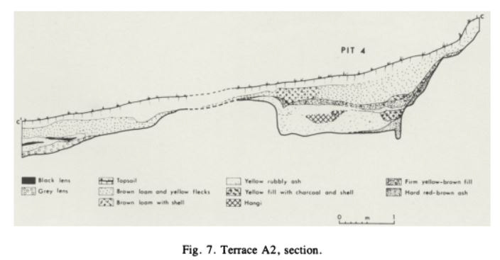
p73, Fig. 7. Terrace A2, section
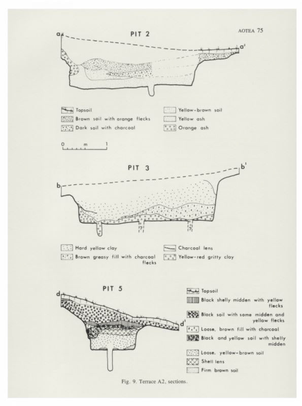
p75, Fig. 9. Terrace A2, sections
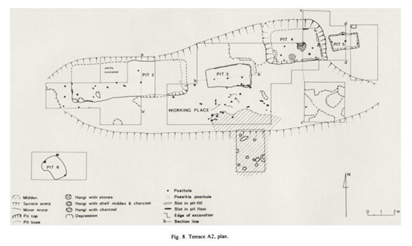
p74, Fig. 8. Terrace A2, plan
“Pit 3 was in the centre of the terrace...with a firm floor of consolidated ash and sandstone. There were three postholes forming a central row for timber uprights to support a ridge pole for the roof. The lowest layer of the filling was a natural accumulation of “reddish-yellow gritty clay” (ash)...sealed down by a thick layer of clean yellow soil in which a seam of charcoal was consipicuous in the cross-section (Fig. 9)....
One curious feature was noticed in this pit and the nearby Pit 4. Along the upper part of the pit sides, there were slots filled with sandy brown soil, 20-30cm deep and in some casers continuing to the pit floor (Fig. 8). This was at first though to be the remains of a lining of plank-like timbers, perhaps split ponga, to prevent slips from the pit sides where it was dug in sandy soil....However, it was concluded later that the slot was the result of the filling not being properly consolidated, consquently soil had slumped inwards from the pit sides creating a space, which subsequently was filled by blown sand and humus.
Pit 4 was dug at the back of the terrace..cooking had taken place in the shelter of the hollow. In the centre there were two hearths, pne above the other with much ash and charcoal, and some shell midden in the upper example. Two hangi at the south end of the pit retained their original filling of heated stones. An obsidian blad (Fig. 20) and a pebble pounder were also found at this level...
Pit 5 was separated from the main terrace...There were no signs of a secondary occupation in this pit...A small greenstone fragment was found in the pit filling, possibly from a chisel...
There was another detached pit (Pit 6) at the south-west end of the terrace...It was an irregular kidney shape..with sides slightly undercut. There were three postholdes in the angles suggesting a tripod-like construction, perhaps for suspension of food in containers as in Pit 1....
The three pits, 2, 3 and 4, took up most of the available space leaving only a narrow stip in front of the terrace...irregular settings of posts suggest that screens or little shelters may have been erected. A triangular setting of three posts may have been supports for a drying rack...It is therefore likely that this was a working place where people sat sheltered from the wind and prepared kumar and other products for pit storage or for drying or cooking. A bone fishhook fragment (Fig. 26), a basalt pebble toold and some pumice fragments were found here.” P73-76
Send us your pledge of support or contact us below:
Thank you!